
Site Analysis
Before implementing an agroforestry project it is prudent to analyze pertinent information about the place and people involved. In the case of the Lill-Nägels Agroforestry Project, I have taken a few steps back from local information in order to provide any international audience the project may garner a bit of wider context.
I have followed a simple rubric for permaculture site analysis which starts with the widest possible lens before examining the farm and site at Lill-Nägels in more detail.
What follows are ten concise analyses intended to provide appropriate information across multiple scales. Together these sketches inform the design process and management. In addition to providing useful information for the development of the pilot project, site analysis serves as a tool for explaining how the site was observed before changes occurred. As a record for “how we saw the place,” site analysis is a crucial facilitator of intergenerational knowledge transfer. In these analyses I have highlighted what I believe to be most important.
Obviously everything could not be included, nor would I try. However, I have found that a comprehensive set of concise analyses to be one of most singularly useful tools for design. It will be clear to observers what I believed to be important and, perhaps, just as important in the long run, what I left out. Holistic design without sufficient site analysis for the project at hand is anything but holistic. An adequately thought through project will, in some sense, design itself once clear goals are set by acting as the natural gatekeeper for agroecological pattern placement.
That said, please note that a site analysis is only part of the design process- a pivotal stage during which information is gathered, made sense of, and finally put to use for directing change. By itself it tells us something about the broader context that a project takes place in. But also- and by design- it leaves out the project’s human context. What it is that the people would like to aim for and achieve requires its own stage of goal setting and conversation. The site analysis, then, serves to inform the decision making process with facts and observations that help give voice to the land itself. If we want to work with the ecosystem, we have to observe and listen.
Global Context
Climate & Weather
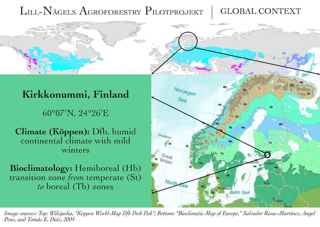
The project is located in Kirkkonummi, Finland. The southernmost region of Finland bordering the Baltic Sea can be characterized ecologically a transition zone between the true temperate forests of central Europe and the vast boreal forest biome which wraps around the northern part of the world all the way from Norway and Sweden across Eurasia and into North America. As the climate generally warms, our region of Finland will be one of the first to accommodate new species life as they move north.
Despite its northern position, Finland clearly benefits from the warming effect created by the North Atlantic Current. When compared to similar latitudes in North America, southern Finland in particular is much warmer and conducive to agriculture. Although agriculture has a long tradition here, its practice is challenged by rapid swings in temperature and very strong seasonal variability. The extreme changes in sunlight duration throughout the year- a result of our high latitude at 60 degrees north- is a challenge which humans do not have any control over.
If one delineates the growing season by conservative climatic data, the growing season can be as short as 90 days even in Kirkkonummi. The last frost date can be as late as the first week of June (only a few weeks before solar midsummer) and the first frost may arrive, as it did during 2022, during the first week of September. With a general warming trend over the last few decades the last frost date has often moved to early May or even late April. For many crops it is possible to take advantage of this change, while taking the risk for others more susceptible to cold can be too large of a gamble.
Summers in Finland are therefore short. The month of June in our region is often cool (highs in the mid 10’s C) with bouts of warmer weather above 20 C. July and August are more predictably warm (>15 C highs), but still not warm enough to raise the mean annual temperature above 6.5 C. The general warming trend seen in our region over the past few decades has set many high temperature records in recent years with June-August all seeing days above 30 C. Given our northern position it only takes a few days of the weather front shifting to bring those temperatures down dramatically as sub-Arctic air is never far away.
The weather at the tail end of the growing season is more predictable than the spring. By mid-September our region sees increasing cloud cover. Although temperatures usually remain above freezing until mid or even late October, the amount of cloud cover coupled with the decreasing day length often means that growth of plants is slowed to a crawl well before the first significant freeze. In the winter, a farmer would do well to assume lows of -25 C as a regular occurrence with temperatures in the -30’s as strongly possible. Taken together, the cool summers and cold winters are still the primary restricting factors for species establishment and commercial viability.
Precipitation is about 650mm per year which is sufficient to support agriculture. However, the distribution of this precipitation is quite uneven. During early spring there is a significant decrease, especially during the key months of April and May when planting begins. Unless a farmer’s practices are conducive to infiltrating and storing snow melt, many farms suffer from drought as soon as the growing season begins. In contrast, the autumn months see increasing levels of precipitation just as the amount of solar energy diminishes. Plants without adequate sunlight cannot make as good use of the water as they would have in the spring and summer. The lack of light- nature’s greatest sanitizer- contributes to poor soil conditions and a variety of pathogen and pest problems.
Socioeconomic Considerations
Finland is a member state of the European Union, which has a significant voice in how agriculture is conducted. Although the population is quite small, GDP per capita is high, thus farmers in Finland face many of the same challenges (and opportunities) found in other economically developed Western countries. Combining socioeconomic pressure with relatively low primary productivity and pronounced unpredictability in weather, farming has become a marginal economic activity with large numbers of farms closing each year. The average age of a Finnish farmer continues to increase without sustainable replacement by younger farmers. Again, this is a characteristic Finland holds in common with many other Western countries that have similar socioeconomic conditions.
Culturally, Finland has a strong tradition of agricultural self-reliance which, although no longer directly pursued politically, still has an impact on consumer choices. Identification with self-reliance and independence are strong motivating factors for consumer and farmer alike, which combined with Finland’s largely rural character and low population density perhaps create conditions where farming as a way of life and esteemed economic activity can be potentially nurtured. This will require that farmers have the necessary monetary resources at their disposal to participate in the wider culture. Put another way, farming needs to become as attractive as other career options. How this can be accomplished is a question many people are working on.
Regional Context
Peri-urbanism
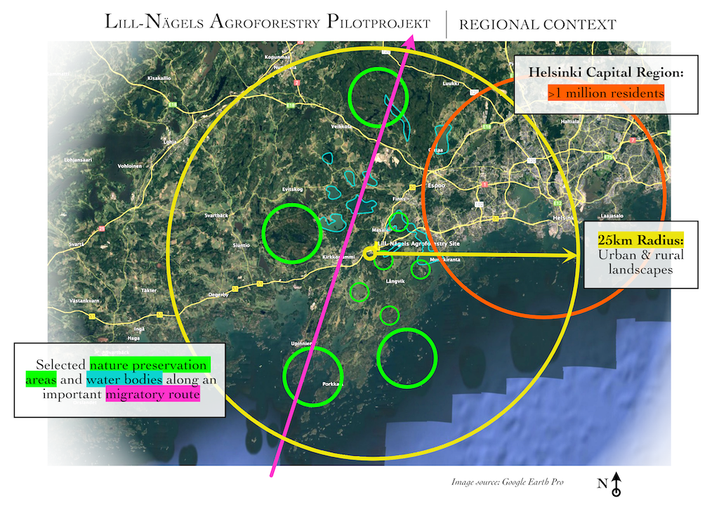
The Lill-Nägels Agroforestry project is situated within the larger Helsinki region. Definitions vary, but the city center of Helsinki is only about 25 km away as the crow flies. As you can see on the map from Google Earth, a highway runs along the southern coast of Finland (highway 51) and it passes just north of the site. In addition, a major ring road (highway 50, commonly known as Ring 3) which operates as a bypass of the city center and more built up areas, joins this highway only a couple of minutes from the site as well. This means that the more than 1 million Finns who reside in the Helsinki area are within a day’s driving distance. Although by some standards one million people is not a very large metropolitan region, in the Finnish context it is one of a kind: ⅕ of the total population live in this area, making it by far the largest urban center in the whole country. The impact this has on our project cannot be easily overstated.
While access to the largest market in Finland provides many economic opportunities, it also weighs down on the other side of the scale by exacerbating the socioeconomic pressure on farmers. Relative inequality- that is, inequality that is readily apparent in daily life- matters more to an individual’s sense of fairness than inequality removed from daily experience. Farmers living in the Helsinki area, however defined, are part of a culture where the expectation for very high standards of living is more ingrained than perhaps anywhere else in the country. Due to the economic opportunities people seek in the Helsinki region, the municipalities on the outside of the core municipalities continue to see population growth. This puts pressure on farmers who, in other areas of the country, likely do not have the same opportunity to sell their land to developers. That farmers in this region know their land is improving in value outside of farming is not a secret, nor is it unique to agricultural lands surrounding growing cities. This economic pressure weighs on the decision making of farmers whether to continue farming or not.
The growth of built up urban areas is readily apparent in this composite image from Google Earth. The highways I mentioned delineate the most obvious border of this expansion in the western part of the Helsinki region. Almost immediately outside of Ring 3 one sees a transition to rural landscape patterning with large areas of cultivated fields and some forests. The greatest pressure to urbanize is taking place along these major transportation corridors, especially those places, like Kirkkonummi, where both road and rail links are already in operation.
Environmental Considerations
Finland has a reputation for a high degree of environmental protection and the area outside of Helsinki is home to more than a handful of national parks. I have chosen to highlight a few nature preservation areas- erasing the difference between a national park proper and a Natura 2000 site in order to emphasize a point: the western region of Helsinki acts as a major birdlife corridor during the migration season. This is in large part due to the presence of the Porkkala peninsula which stretches, when you include some of the larger outlying islands, a good 25 km south-southwest from the Lill-Nägels site,. This peninsula shortens the journey for birds crossing the Gulf of Finland considerably (by about 20 km) and thus is an important air bridge to the rest of Europe and beyond.
A string of nature sites with varying degrees of protection serve as arrival and departure habitats for many birds that find their home elsewhere in the country during the short summers. Recognizing the significance that this area plays for bird life and the ecological consequences of preserving that biodiversity is an important part of expanding a farmer’s view of how they could manage their land. Support for environmental policies runs high in the Helsinki area and thus, in addition to the socioeconomic pressure to perform profitability and competitively, farmers who live and work here are those under the closest scrutiny by urban citizens.
Given that the farms under management by the owner of the Lill-Nägels site are literally right next to major commuter highways and rail networks means that they serve doubly as ambassadors for farming to the broader community. Every day tens of thousands of people- of all ages and backgrounds- see these farms (but not the project site). The potential for passive positive influence is high. By the same token, the opportunity to negatively influence people’s perceptions of farming is just as present. Even if the amount of time available for that passive influence is low (the trains travel 100 km/hr or so), that does not take away from the fact that the site is but a day’s trip by public transport for almost anyone in the region. With outreach programs, farmers in this region who are situated along transport corridors have, at least in theory, the opportunity to directly engage the local population for trade or education.
Additionally the Baltic Sea plays a very large role here as Finland’s coastline is characterized by many small inlets and bays with thousands of islands. Some consider this region to be the easternmost border of the Finnish archipelago. It is well known that the Baltic Sea is one of the most polluted water bodies in the world- largely due to its extremely low exchange rate with the North Sea. Agricultural runoff is a primary contributor to the Baltic Sea’s poor state. Every country surrounding the Baltic is contributing and those farmers, wrongly or rightly, who are closest to the sea are again those who bear the brunt of the public’s attention. When you are adjacent to the Baltic Sea or a river flowing into it, being able to engage the public directly with how you are working to not just reduce your negative impact, but rather perhaps even become a positive influence on the sea’s state, can become an important part of a farm’s branding in a market characterized by strong environmental awareness.
Capitalizing on the growing awareness about agriculture’s impact on the environment is possible when you take into consideration the proximity of those very same interested parties to the farm itself. This is a unique opportunity present at this farm and others like it in the area. It may be possible to think beyond primary production and into agri- and nature tourism as ways to supplement farm income- again, in a region where farm income must remain competitive in order to survive in an urbanizing region.
Neighborhood Context
Lill-Nägels Agroforestry Neighborhood Context 1/2
As we get closer to the site the intersection of my discussion of transport links, urbanization, and natural migratory routes becomes more clear.
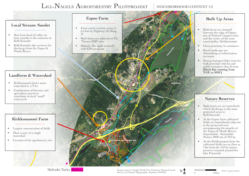
The farm is divided between two places: what I’ve labeled as the Espoo Farm, located at the extreme north east of the figure, and the Kirkkonummi Farm, at the opposite end of the focus ring. The farm in Kirkkonummi is larger than that in Espoo and the two are under ten minutes apart by car. There are two farm centers due to the armistice- which ended hostilities between the former Soviet Union and Finland- after the Second World War which leased the Porkkala peninsula to the USSR for a period of time as a military base. It is an interesting history worth exploring on its own whose occurrence plays a role in the urbanization story of this area in addition to its impacts on families due to displacement.
The built up areas circled in yellow have a clear relationship to the transport links (yellow highways and the black dashed line representing the rail line). Other, smaller roads, provide access to neighborhoods and population centers just a few minutes away from the site. While currently small in comparison to other built up areas- for example, the large semicircle representing the western edge of Espoo, has a much higher population density than this part of Kirkkonummi- these are rapidly growing neighborhoods with new apartment buildings and other construction taking place. Many families with children move to Kirkkonummi for a slightly lower cost of living and this area in particular, given its proximity to Helsinki proper, is naturally in demand.
That these areas are expanding at the expense of farm land and putting pressure on what remains of semi-natural areas (most of Finland is not natural forest, but rather managed forestry plots) is readily apparent at the confluence of the two highways next to the site. Despite farmland generally not offering much by way of habitat, there is a degree of ecosystem services provided by even industrial agriculture that plays an important edge effect role in the peri-urban environment. The loss of open landscapes and the edges of scrubland that develop around many fields reduces habitat in favor of hardscapes, light pollution, and other environmental effects of urbanization.
The complex geography of a land shaped by glacial retreat and rebound is on full display with Finnträsk- a large lake immediately adjacent to the farm boundary- outflowing to the south while the farm itself sends its water north and northeast to Kallviksundet, the small bay to the north. Coincidentally both the Espoo and the Kirkkonummi farm contribute to the water flow into this 222 hectare Natura 2000 protected zone even though they are separated by 6,5 kilometers. The lake, Finnträsk, has a 154 hectare preserve mostly located to its south, but also compromising a smaller old forest section on the north bank which could be very interesting to visit.
The distance from the head of the valley in Lill-Nägels (highlighted in orange by the Landform and Watershed text) to the estuaries that flow into Kallviksundet is only about four kilometers. Although the farm is not the only contributor to this catchment (and its contribution is changed considerably due to the water engineering around the highway), it always a good idea to trace a site’s water lineage to the highest point in the watershed as well as downstream to get an idea as to how the place is connected to this most valuable resource.
Lill-Nägels Agroforestry Neighborhood Context 2/2
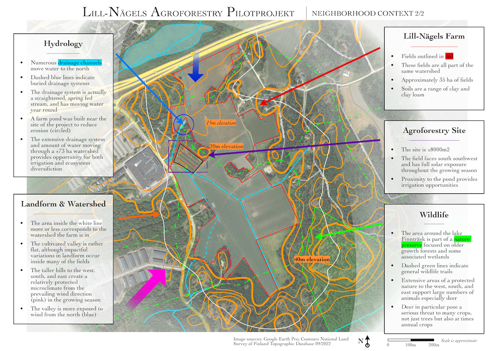
The last neighborhood analysis takes us to the Lill-Nägels valley. Here I have simply rescaled the same features to gain insight into how the site itself relates to the landform and water moving through the land.
The valley gently slopes downhill towards the north starting at its head. The land does not begin to drop off quickly until the last section just north of the farm pond. Here the elevation changes rapidly before reaching the valley bottom where the highway runs.
Standard practice of ditching the edges of fields and straightening existing streams is evident. All of the ditches lead down slope and converge near the project site, located in the center left of the figure. Here the on farm ditches, many of which run with water year round and are fed by springs in the surrounding hills, are joined by runoff systems for the road and factory across the street to the west. Thirty-five hectares of fields drain through this singular watershed before entering the pond. As indicated in the figure, the pond is a purpose-built feature that arrests the surface flow before the area of high erosion risk and channels it into the built environment downhill.
This pond is a good source of irrigation water for agroforestry systems in that the water, when reapplied to tree systems, will be going to perennial agroecosystems which generally develop deeper soils with higher water storage capacity than soils under annual cultivation.
Since this part of the farm operates mostly in a single valley there is an opportunity to demonstrate multiple kinds of water management techniques which could increase habitat and provide valuable ecosystem services from valley head to valley floor. As long as the relatively hilly landscape around the valley remains forested, even under conventional forestry practices, the valley will be supplied by large amounts of groundwater.
Only the northern edge of the valley is relatively unprotected from strong winds: the rest of the fields have high, forested hills that reduce wind speed and offer shelter. The size of open ground, however, means that winds do have the chance to pick up speed once again and cause wind related stress to crops. In particular the project site is exposed to wind from the southeast for just over 600 uninhibited meters.
Lastly, the large amount of forest and edge-landscapes around the farm, in addition to the protected areas and ample water, lead to quite high populations of deer and other wild animals that can- and do- cause damage to crops. I have repeatedly observed about two dozen deer grazing at the southern edge of this valley at any one time. It was for this reason that we prioritized a proper game fence to protect the pilot project. Fencing the entire valley is out of the question and other tree protection measures would need to be considered for large scale implementation of lessons from the project.
Site Specific Analyses
With that background it is now time to turn to the site itself. I have chosen to employ a range of common permaculture site analysis topics, while leaving out “aesthetics,” “current zones of use,” and most notably “soil.” Soil will be addressed on its own with the presentation on soil pits and laboratory analysis.
Landform
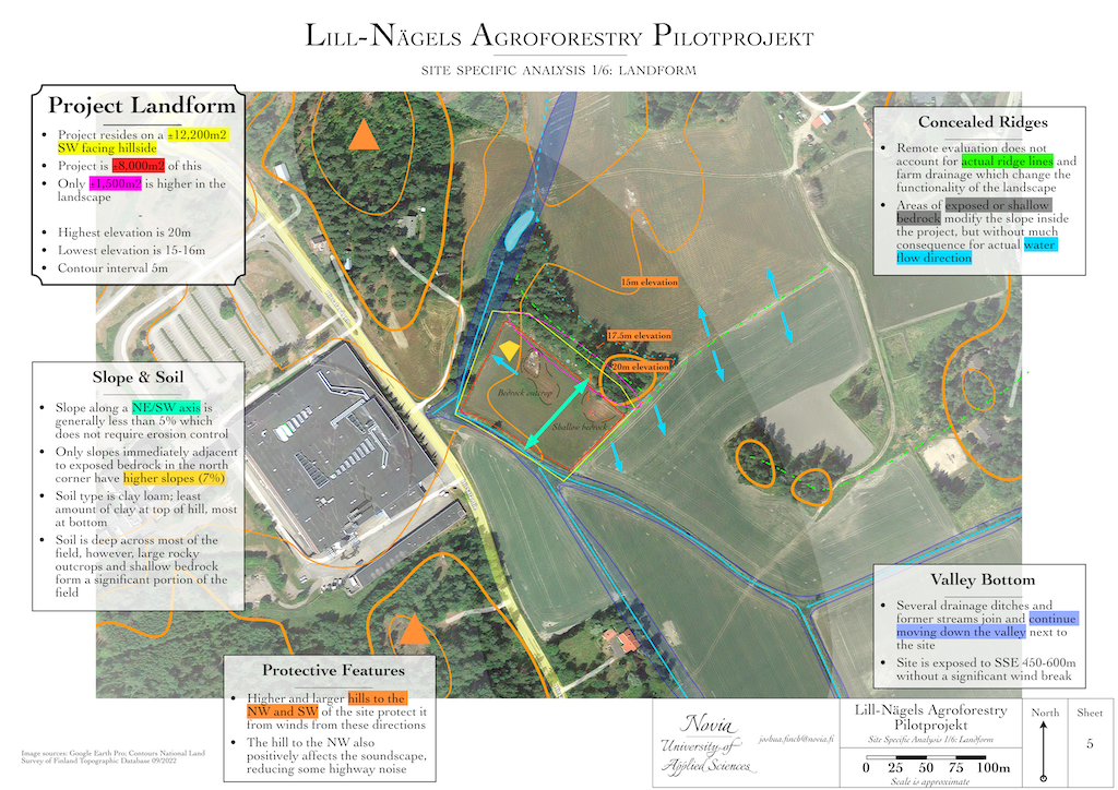
Examining the landform of the site- that is, aspects related to its geographic features such as elevation, shape, aspect, size, and the relationships they have to the ecology of the site- is an important first step. Although water may be the most important resource for many projects, if you don’t understand the shape of the land that the water is interacting with design errors are more likely.
I have used orange lines to demarcate contour lines as provided by the National Land Survey. The scale of their survey is insufficient for detailed site planning, but it is more than adequate for understanding the basic geographic features of a site of this size and how they relate to the surrounding land. I’ve added supplemental, directly observed ridges to the figure using dashed green lines. Blue arrows indicate how the longest of these ridges directs water: without the ridge running northeast from the site, one would imagine that much of the field (green with crop growth) would have sent surface flows to the north, not the south. However, this is not the case and the “extra” water diverted into the drainage system of the valley means that it is partially captured and stored by the pond spoken of before.
The most important ridge, for our project’s sake, is that which runs from the top of the hill immediately adjacent to the site’s northeast down the wooded hill towards the pond. This wooded ridge is important because it reveals how the site is actually situated on a southwest facing, stand alone micro water catchment. The only potential surface water moving to this site is from this ridge. Given that the ridge has mature mixed trees growing there since the 1950's (secondary succession post-Soviet occupation), only the most severe weather events will likely see surface water movement from above the site. The yellow line corresponds approximately to size of this hillside: ±12,200 m2. As the project is about 8,000m2, then 65% of this hillside is under our direct management with only an additional 1,500m2 or so above the field. This means that the trees and plants will only have access to the precipitation that falls on site: deep rooted perennials will not have the chance to intercept groundwater flows coming down from higher elevations.
Combine this with the mostly southwestern facing aspect of the slope and you have a hot and dry microclimate. Once you factor in the areas of shallow and exposed bedrock into the equation it is little wonder that the field was removed from conventional agricultural farming and placed into an environmental scheme.
These facts present design challenges, not insurmountable obstacles, and agroforestry is a very suitable concept to draw agronomic patterns from that can help alleviate some of these underlying issues.
We will be aided in this effort by the fact that the landform on the project field is relatively flat, except where indicated by a yellow diamond. A gentle slope eases mobility through the site and makes mechanization a lot safer and straightforward. The project field is about 2x as long as it is wide: once the fence was erected, the northern perimeter measures 123,5m and the east/southeast edge of the field is 67,5m.
In addition, the soil has a high clay content (25-30+%) which, even without sufficient soil organic matter, has high natural water holding capacity. The areas of shallow soil will prove challenging but they only comprise about 25% of the project.
Water
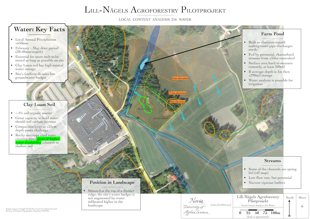
This may sound odd, but since water is inexorably tied to the other facets of the location and is addressed in relation to them, I will not spend much time addressing it directly.
The most important thing about water for this site, besides the low amount available without intervention, is the proximity to the farm pond. The pond is only about 175 meters from the highest point of the ridge at the northeastern edge of the site. With a surface area of approximately 300 m2 and continual recharge, it may contain anywhere from 150-300 m3 of water at any one time. Investigation of historical imagery, before tree cover increased, yields a surface area anywhere from 750 - 850m2.
We have calculated that, with attention to ground cover and minimal soil disturbance, we may only use about 16 m3 per irrigation session. Even if we were to double the amount of water applied and increase the frequency of application the pond should have enough capacity. Although I will address irrigation directly in other parts of this project, I will note that we had the water tested with a “raw water analysis” by an accredited laboratory and the water is fit for irrigation purposes.
It may be possible to utilize a ram pump installed in the stream to send water to holding tanks at the top of the ridge and utilize a gravity irrigation system to reduce or eliminate electrical pumping of water.
In a testament to soil compaction and underlying bedrock, a small pool (a pit, really) is located in the saddle where the gas line was buried. This pool holds water for the whole year and has already been colonized by bulrushes. It may need to be drained (or expanded?) to reduce mosquito populations.
Access & Circulation
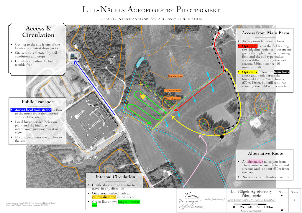
Access is an all too often ignored characteristic of a site. How one gets to, around, and through a site is of utmost importance for the long term viability of a system. Changes to access to accommodate machinery are expensive and require in depth planning to make them last.
In this figure I have drawn two primary options for reaching the site from the main farm area: (A) down the farm track and cutting across the ridge or, (B) following the farm track all the way to its terminus and then turning west northwest to the site. Option B is a lot longer, but would reduce impact on growing crops if taken with a tractor. Since the site will be “out of sync” with the rest of the fields it will require, at times, damage to crops in the transit fields unless permanent tram lines are introduced or a new farm track is created, for example, across the ridge.
It is my estimation that access to the site is the project’s greatest inherent drawback. Moving tools and supplies by hand or wheelbarrow is cumbersome especially during the autumn when the soil is wet. Even Option A is about 350 meters of walking and crossing ditches. This is one aspect as to why the site is most suited for a silvoarable agroforestry system with cultivation of broad acre, long season crops as the focus rather than integrating a large number of faster growing annuals such as vegetables into the pilot project.
An alternative route is also sketched in that follows existing routes, but it is only provided to illustrate other ways of approach.
Once you arrive at the site, internal circulation is eased by the gentle slope of the hill. Only the area marked with a yellow diamond is too steep for the tractor and increases risk of an accident. Therefore we have delineated, in the design, an exclusion zone around it where we will not grow crops and likely will only need to mow occasionally.
Arriving at the site by car to the main farm area is straightforward and poses little difficulty. Arrival by public transport is also straightforward as connections to the commuter train line and a local bus stop servicing the Ericsson plant just west of the project are available. One does need to cross the stream in order to reach the site, but it is not very wide and a small, single plank bridge could easily be laid across.
Vegetation & Wildlife
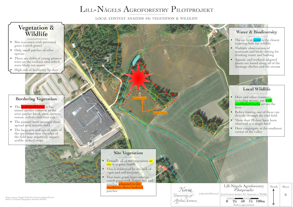
Now let’s turn to the aboveground, biological side of things. As mentioned previously, the field has been taken out of cash crop rotations and set aside in an environmental scheme. It was planted with perennial grasses in 2019 with annual mowing for management.
Inside the field there is a distinct lack of species diversity, which is a key reason the soil has not improved much despite no longer being cultivated. Perennial nonwoody plants have been shown to do best in combination with at least four plant families growing such that their roots intermingle. Polycultures allow the plants and their microbiomes to cooperate closely and more fully utilize the incoming solar energy. With the grasses growing as a monoculture they do not have diverse partners to interact with and are more subject to competition.
The areas with shallow bedrock and rocky soil have been colonized by a different species of grass which does make demarcating these unfavorable sites easier.
Surrounding the field on two of four sides is a small forest. The current forest is not very old, although the hill itself has been forested for centuries. It was cut down during the Soviet tenure and by the 1970’s the hill was reforested, putting the age of some of the trees to about 66 years. The western edge of the forest, which runs along the stream, is younger, having sprung up around the year 2000. Despite their relatively young age, these trees have long since reached maturity and send seeds, especially of pioneer species like poplar and birch, into the field. In addition, their proximity to the edges of the field likely mean that they have root systems in the margins, which may create issues with management. Active management- pruning, felling, etc- of the woodland may become necessary to provide disturbance events to reduce pressure on the field.
Aquatic plant and animal species are found along the streams which border the site and of course in the farm pond. Their number and diversity could be increased to provide more ecosystem services to the surrounding farmland. The pond and stream both provide drinking water to the area’s fauna.
Turning to animal wildlife, both birds and mammals are in large numbers. With the pond being so close by, the animals have established tracks through the fields which lead from cover to cover and down to the pond. It is not uncommon to see deer and other forest animals feeding in the fields and drinking from the water in the valley. Wildlife pressure on young trees is tremendously high even with hunting taking place on the farm.
A wide variety of birds call the area home- the farm provides a large amount of open land with earlier succession species and open lands for perennial forbs and grasses to grow, which helps differentiate their diet and provides habitat for raising young. The presence of ravens attests to the mosaic of forest and open land habitats in the area. Migratory species like cranes and swans also use the valley, but I have not noticed them venturing as far north near the busy roads, so they tend to stay near the southern end of the valley.
Buildings & Infrastructure
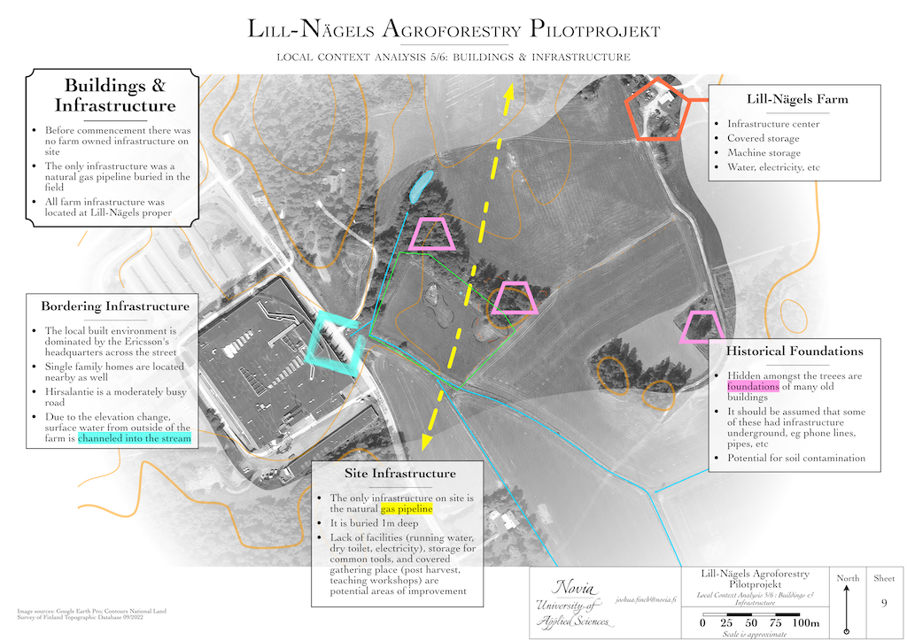
Prior to initiation of the project there were no farm buildings or infrastructure on the site. The only preexisting infrastructure is a natural gas pipeline that was constructed in 2017.
This area of Kirkkonummi has been inhabited and farmed for centuries, with the local names which eventually became Jorvas and Nägels dating back to the earliest map I have available which is from 1776. What is now Lill-Nägels Farm has buildings associated with it as far back as this and the valley has been in cultivation since at least the 16th century. To this day the cluster of houses and farm buildings remains the center of activity, the permaculture zone 0 and 1 of the farm. This project does not concern itself with changes to these zones.
With a history spanning more than 200 years, it makes sense that there are remnants of old houses, outbuildings, and other infrastructure around the site. With historical imagery and maps covering this period we can attest that there are “ruins” around the site, especially on the raised bits of hills in the area. The foundations indicated in this figure are approximate. A lot of infrastructure is left from what appears to be the Soviet period and can pose a tripping hazard (exposed wires etc) if you walk in the little forest. What is buried in the soil here is anyone’s guess.
The road which runs along the western edge of the figure has also existed since at least 1776 and the drainage ditch at the bottom of the hill which sends water into the stream system is mapped as far back as 1870.
Alongside access, the lack of infrastructure on the site are limiting factors for site development. Without access to electricity from the grid, any irrigation system utilizing pumps and water from the pond will need a generator or be powered by a tractor’s PTO unit. Since irrigation is key, lack of electricity may be a strong limiting factor. However, the need for electricity otherwise on site is very low and would be a luxury. Clean water to wash produce, clean tools, or for personal hygiene is an issue to be addressed. Given the scope of the project’s goals, this could be rectified with a small amount of water storage: clean water can be brought from elsewhere and kept in a container for use.
There are also no buildings on the site. A shed for storing common tools, getting out of the rain, and providing an alternative permaculture zone 0-1 would be useful for facilitating the applied research on site. If a CSA is developed and people want to pack their produce, a level area with tables and benches could be helpful for people to gather, stay, and process their harvest. Most likely this could be situated on the eastern edge of the project.
Perhaps more importantly, a dry toilet with access to clean water and a small graywater system would go a long way towards improving usability of the site.
Microclimates
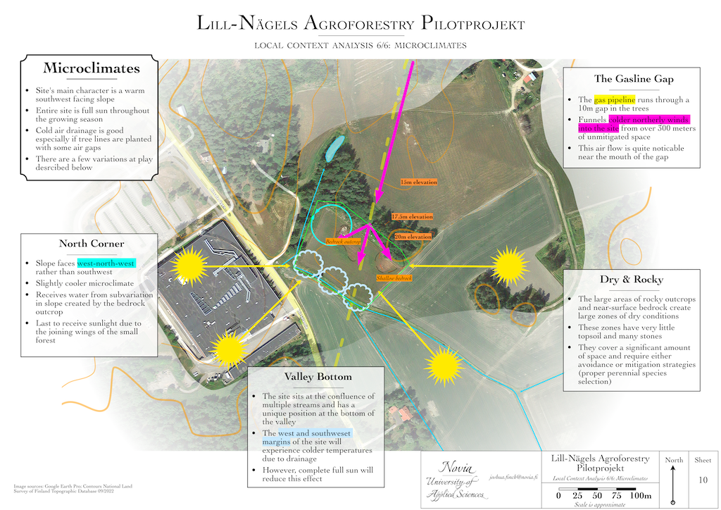
Our final site analysis considers the microclimates of the place. As mentioned in the landform section, the field faces southwest. In our part of the world, this aspect creates the warmest microclimate: the ambient temperature rises throughout the morning and by the time direct solar energy reaches the land in the afternoon, the temperature can rise rapidly. The clear and relatively level land to the southeast through to the west ensures that the site receives full sun throughout the day, making this microclimate even warmer.
Since the site is slightly sloping with about four meters of elevation change, there is ample cold air drainage. This cool air may accumulate in the valley bottom where the land drops off to the stream bed, and will cause some notable temperature variation during the shoulder seasons of spring and summer in particular.
The land does change form a bit in the west-north-west corner of the site and therefore is noticeably cooler than elswhere. In addition to no longer directly facing the sun during the day, it is lower in elevation so it is cooler. One can see the effect on the grass growth, especially during the 2022 drought, with darker green grass and better overall growth. Still, it would not be considered cold.
One thing that is interesting about that small pocket is that (alongside the other areas directly adjacent to shallow soil) they have more water available to them than the majority of the site. This is evident throughout the historical imagery of sufficient quality to see the color shift. The shallow, compacted, and rocky soil sheds water much like a hardscape and thus increases the total amount of water in the areas it runs into.
Due to the trees wrapping the site from the northern exposures, the place is even warmer than it would be without them protecting the field from colder wind. There is an exception to this, noted in pink, where the gas pipeline runs. There is a small treeless corridor, about 10 meters wide, that allows cold air to rush into the field from the north northeast. It is noticeably more turbulent and cooler there. Whether this gap can be “plugged” with more trees is unknown at the time of writing.
Despite this cold air gap, the site’s exposure to full day sun throughout the growing season, and its orientation being roughly east-west, means that it may be well suited for growing species which are limited by heat in our climate. Pears and even table grapes should produce viable crops for the purposes of a pilot project. As the soil improves across the whole site, the addition of tree lines will help reduce wind speed further and create new microclimates. It will be interesting to see how this will affect alley cropping.
Conclusion
Taken together, these analyses point to the site being favorable for the development of an agroforestry pilot project. The few disadvantages of the site- poor soil fertility, soil compaction, and lack of infrastructure are not insurmountable obstacles. In fact, the first two of these are relatively easy to change through human action. Changing the soil’s fertility is one of the key goals of the pilot project.
The site’s landform, along with its proximity to running water of irrigation quality, are things that we would not be able to change. That they are both favorable to trialing new agroforestry systems weighs strongly in the site’s favor.
In addition, the ease of access to the location for site visits is a worthwhile consideration when starting a new project. Proximity to market and visibility are important factors from both a farming and project development point of view.
With modest improvements to access and infrastructure, the site appears quite conducive for our purposes.
For ease of navigation, if you are interested to read about the design of the site, click here.